Earth Spheres
Lithosphere/Geosphere
The lithosphere contains all of the cold, hard solid land of the planet's crust (surface), the semi-solid land underneath the crust, and the liquid land near the center of the planet. The solid, semi-solid, and liquid land of the lithosphere form layers that are physically and chemically different. If someone were to cut through Earth to its center, these layers would be revealed like the layers of an onion
Biosphere
The biosphere contains all the planet's living things. ***This sphere includes all of the microorganisms, plants, and animals of Earth.
Within the biosphere, living things form ecological communities based on the physical surroundings of an area. These communities are referred to as biomes. Deserts, grasslands, and tropical rainforests are three of the many types of biomes that exist within the biosphere.
Within the biosphere, living things form ecological communities based on the physical surroundings of an area. These communities are referred to as biomes. Deserts, grasslands, and tropical rainforests are three of the many types of biomes that exist within the biosphere.
Atmosphere
The atmosphere contains all the air in Earth's system. ****It extends from less than 1 m below the planet's surface to more than 10,000 km above the planet's surface. The upper portion of the atmosphere protects the organisms of the biosphere from the sun's ultraviolet radiation. It also absorbs and emits heat. When air temperature in the lower portion of this sphere changes, weather occurs. As air in the lower atmosphere is heated or cooled, it moves around the planet. The result can be as simple as a breeze or as complex as a tornado.
hydrosphere
The hydrosphere is composed of all of the water on or near the earth. This includes the oceans, rivers, lakes, and even the moisture in the air. Ninety-seven percent of the earth's water is in the oceans. The remaining three percent is fresh water; three-quarters of the fresh water is solid and exists in ice sheets

Earth's Layers
crust
The Earth's Crust is like the skin of an apple. It is very thin in comparison to the other three layers. The crust is only about 3-5 miles (8 kilometers) thick under the oceans(oceanic crust) and about 25 miles (32 kilometers) thick under the continents (continental crust). The temperatures of the crust vary from air temperature on top to about 1600 degrees Fahrenheit (870 degrees Celcius) in the deepest parts of the crust. You can bake a loaf of bread in your oven at 350 degrees Fahrenheit , at 1600 degrees F. rocks begin to melt.
mantle
The mantle is a part of a terrestrial planet or other rocky body large enough to have differentiation by density. The interior of the Earth, similar to the other terrestrial planets, is chemically divided into layers. The mantle is a layer between the crust and the outer core.
core
The inner core of the Earth, its innermost part, is a primarily solid ball with a radius of about 1,220 km (760 mi), according to seismological studies.[1][2] (This is about 70% of the Moon's radius.) It is believed to consist primarily of an iron–nickel alloy, and to be about the same temperature as the surface of the Sun: approximately 5700 K (5430 °C)
The outer core of the Earth is a liquid layer about 2,266 km (1,408 mi) thick composed of iron and nickel which lies above the Earth's solid inner core and below its mantle. Its outer boundary lies 2,890 km (1,800 mi) beneath the Earth's surface. The transition between the inner core and outer core is located approximately 5,150 km (3,200 mi) beneath the Earth's surface.
The outer core of the Earth is a liquid layer about 2,266 km (1,408 mi) thick composed of iron and nickel which lies above the Earth's solid inner core and below its mantle. Its outer boundary lies 2,890 km (1,800 mi) beneath the Earth's surface. The transition between the inner core and outer core is located approximately 5,150 km (3,200 mi) beneath the Earth's surface.

Topographical map (longitude, latitude)
Latitude and longitude is the most common grid system used for navigation. It will allow you to pinpoint your location with a high degree of accuracy. Latitude is the angular distance measured north and south of the Equator. The Equator is 0 degrees. As you go north of the equator the, latitude increases all the way up to 90 degrees at the north pole. If you go south of the equator, the latitude increases all the way up to 90 degrees at the south pole. In the northern hemisphere the latitude is always given in degrees north and in the southern hemisphere it is given in degrees south.Longitude works the same way. It is angular distance measured east and west of the Prime Meridian (which has been arbitrarily set at Greenwich, England). The prime meridian is 0 degrees longitude. As you go east from the prime meridian, the longitude increases to 180 degrees. As you go west from the prime meridian longitude increases to 180 degrees. The 180 degree meridian is also known as the international date line. In the eastern hemisphere the longitude is given in degrees east and in the western hemisphere it is given in degrees west.
Minerals (properties, characteristics)
A mineral is a naturally-occurring, inorganic solid which possesses a characteristic internal atomic structure and a definite chemical composition.
If we take the definition of a mineral term by term, it becomes easier to understand.
If we take the definition of a mineral term by term, it becomes easier to understand.
- Minerals must occur naturally. This means man-made substances such as steel aren't minerals.
- Inorganic substances are those substances that are not living and are not formed by living processes.
- Crystalline solids are those solids in which the atoms composing the solid have an orderly, repeated pattern.
- Minerals will have definite chemical compositions, but these compositions may vary within given limits.
Rock cycle
igneous
This article needs additional citations for verification. Please help improve this article by adding citations to reliable sources. Unsourced material may be challenged and removed. (November 2012) Geologic provinces of the world (USGS) Shield Platform Orogen Basin Large igneous province Extended crust Oceanic crust: 0–20 Ma 20–65 Ma >65 Ma Igneous rock (derived from the Latin word ignis meaning fire) is one of the three main rock types, the others being sedimentary and metamorphic rock. Igneous rock is formed through the cooling and solidification of magma or lava. Igneous rock may form with or without crystallization, either below the surface as intrusive (plutonic) rocks or on the surface as extrusive (volcanic) rocks. This magma can be derived from partial melts of pre-existing rocks in either a planet's mantle or crust. Typically, the melting is caused by one or more of three processes: an increase in temperature, a decrease in pressure, or a change in composition. Over 700 types of igneous rocks have been described, most of them having formed beneath the surface of Earth's crust.
metamorphic
Metamorphic rocks arise from the transformation of existing rock types, in a process called metamorphism, which means "change in form". The original rock (protolith) is subjected to heat (temperatures greater than 150 to 200 °C) and pressure (1500 bars),[1] causing profound physical and/or chemical change. The protolith may be sedimentary rock, igneous rock or another older metamorphic rock.
Metamorphic rocks make up a large part of the Earth's crust and are classified by texture and by chemical and mineral assemblage (metamorphic facies). They may be formed simply by being deep beneath the Earth's surface, subjected to high temperatures and the great pressure of the rock layers above it. They can form from tectonic processes such as continental collisions, which cause horizontal pressure, friction and distortion. They are also formed when rock is heated up by the intrusion of hot molten rock called magma from the Earth's interior. The study of metamorphic rocks (now exposed at the Earth's surface following erosion and uplift) provides information about the temperatures and pressures that occur at great depths within the Earth's crust. Some examples of metamorphic rocks are gneiss, slate, marble, schist, and quartzite.
Metamorphic rocks make up a large part of the Earth's crust and are classified by texture and by chemical and mineral assemblage (metamorphic facies). They may be formed simply by being deep beneath the Earth's surface, subjected to high temperatures and the great pressure of the rock layers above it. They can form from tectonic processes such as continental collisions, which cause horizontal pressure, friction and distortion. They are also formed when rock is heated up by the intrusion of hot molten rock called magma from the Earth's interior. The study of metamorphic rocks (now exposed at the Earth's surface following erosion and uplift) provides information about the temperatures and pressures that occur at great depths within the Earth's crust. Some examples of metamorphic rocks are gneiss, slate, marble, schist, and quartzite.
sedimentary
From Wikipedia, the free encyclopedia Jump to: navigation, search Middle Triassic marginal marine sequence of siltstones (below) and limestones (above), Virgin Formation, southwestern Utah, USA Sedimentary rocks are types of rock that are formed by the deposition of material at the Earth's surface and within bodies of water. Sedimentation is the collective name for processes that cause mineral and/or organic particles (detritus) to settle and accumulate or minerals to precipitate from a solution. Particles that form a sedimentary rock by accumulating are called sediment. Before being deposited, sediment was formed by weathering and erosion in a source area, and then transported to the place of deposition by water, wind, ice, mass movement or glaciers which are called agents of denudation.
The sedimentary rock cover of the continents of the Earth's crust is extensive, but the total contribution of sedimentary rocks is estimated to be only 8% of the total volume of the crust.[1] Sedimentary rocks are only a thin veneer over a crust consisting mainly of igneous and metamorphic rocks. Sedimentary rocks are deposited in layers as strata, forming a structure called bedding. The study of sedimentary rocks and rock strata provides information about the subsurface that is useful for civil engineering, for example in the construction of roads, houses, tunnels, canals or other constructions. Sedimentary rocks are also important sources of natural resources like coal, fossil fuels, drinking water or ores.
The study of the sequence of sedimentary rock strata is the main source for scientific knowledge about the Earth's history, including palaeogeography, paleoclimatology and the history of life. The scientific discipline that studies the properties and origin of sedimentary rocks is called sedimentology. Sedimentology is both part of geology and physical geography and overlaps partly with other disciplines in the Earth sciences, such as pedology, geomorphology, geochemistry or structural geology.
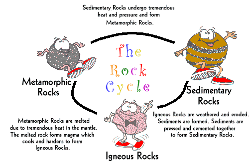
Plate Tectonics
Earthquakes
An earthquake (also known as a quake, tremor or temblor) is the result of a sudden release of energy in the Earth's crust that creates seismic waves. The seismicity, seismism or seismic activity of an area refers to the frequency, type and size of earthquakes experienced over a period of time.
Earthquakes are measured using observations from seismometers. The moment magnitude is the most common scale on which earthquakes larger than approximately 5 are reported for the entire globe. The more numerous earthquakes smaller than magnitude 5 reported by national seismological observatories are measured mostly on the local magnitude scale, also referred to as the Richter scale. These two scales are numerically similar over their range of validity. Magnitude 3 or lower earthquakes are mostly almost imperceptible or weak and magnitude 7 and over potentially cause serious damage over larger areas, depending on their depth. The largest earthquakes in historic times have been of magnitude slightly over 9, although there is no limit to the possible magnitude. The most recent large earthquake of magnitude 9.0 or larger was a 9.0 magnitude earthquake in Japan in 2011 (as of October 2012), and it was the largest Japanese earthquake since records began. Intensity of shaking is measured on the modified Mercalli scale. The shallower an earthquake, the more damage to structures it causes, all else being equal.[1]
At the Earth's surface, earthquakes manifest themselves by shaking and sometimes displacement of the ground. When the epicenter of a large earthquake is located offshore, the seabed may be displaced sufficiently to cause a tsunami. Earthquakes can also trigger landslides, and occasionally volcanic activity.
In its most general sense, the word earthquake is used to describe any seismic event — whether natural or caused by humans — that generates seismic waves. Earthquakes are caused mostly by rupture of geological faults, but also by other events such as volcanic activity, landslides, mine blasts, and nuclear tests. An earthquake's point of initial rupture is called its focus or hypocenter. The epicenter is the point at ground level directly above the hypocenter.
P and S waves
P-waves are a type of elastic wave, called seismic waves in seismology, that can travel through a continuum. The continuum is made up of gases (as sound waves), liquids, or solids, including the Earth. P-waves can be produced by earthquakes and recorded by seismographs. The name P-wave is often said to stand either for primary wave, as it has the highest velocity and is therefore the first to be recorded; or pressure wave,[1] as it is formed from alternating compressions and rarefactions.
In isotropic and homogeneous solids, the mode of propagation of a P-wave is always longitudinal; thus, the particles in the solid have vibrations along or parallel to the travel direction of the wave energy.
A type of elastic wave, the S-wave, secondary wave, or shear wave (sometimes called an elastic S-wave) is one of the two main types of elastic body waves, so named because they move through the body of an object, unlike surface waves.
The S-wave moves as a shear or transverse wave, so motion is perpendicular to the direction of wave propagation: S-waves are like waves in a rope, as opposed to waves moving through a slinky, the P-wave. The wave moves through elastic media, and the main restoring force comes from shear effects. These waves do not diverge, and they obey the continuity equation for incompressible media:
epicenter
The epicenter or epicentre /ˈɛpɪsɛntər/ is the point on the Earth's surface that is directly above the hypocenter or focus, the point where an earthquake or underground explosion originates.
focus
The world's earthquakes are not randomly distributed over the Earth's surface. They tend to be concentrated in narrow zones.
An explanation is to be found in plate tectonics, a concept which has revolutionized thinking in the Earth's sciences in the last 10 years.
Plate tectonics tells us that the Earth's rigid outer shell is broken into a mosaic of oceanic and continental plates which can slide over the plastic aesthenosphere, which is the uppermost layer of the mantle. The plates are in constant motion.
The lithosphere covers the whole Earth. Therefore, ocean plates are also involved, more particularly in the process of sea-floor spreading. This involves the midocean ridges which are a system of narrow submarine cracks that can be traced down the center of the major oceans. The ocean floor is being continuously pulled apart along these midocean ridges. Hot volcanic material rises from the Earth's mantle to fill the gap and continuously forms new oceanic crust. The midocean ridges themselves are broken by offsets know as transform faults.
faults
n geology, a fault is a planar fracture or discontinuity in a volume of rock, across which there has been significant displacement along the fractures as a result of earth movement. Large faults within the Earth's crust result from the action of earthquakes , with the largest forming the boundaries between the plates, such as subduction zones or transform faults. Energy release associated with rapid movement on active faults is the cause of most earthquakes.
divergent
layers of lithosphere are pulled apart. Plate separation is a slow process. For example, divergence along the Mid Atlantic ridge causes the Atlantic Ocean to widen at only about 2 centimeters per year.
convergent
laces where plates crash or crunch together are called convergent boundaries. Plates only move a few centimeters each year, so collisions are very slow and last millions of years. Even though plate collisions take a long time, lots of interesting things happen. For example, in the drawing above, an oceanic plate has crashed into a continental plate. Looking at this drawing of two plates colliding is like looking at a single frame in a slow-motion movie of two cars crashing into each other.
transverse plates
Places where plates slide past each other are called transform boundaries. Since the plates on either side of a transform boundary are merely sliding past each other and not tearing or crunching each other, transform boundaries lack the spectacular features found at convergent and divergent boundaries. Instead, transform boundaries are marked in some places by linear valleys along the boundary where rock has been ground up by the sliding. In other places, transform boundaries are marked by features like stream beds that have been split in half and the two halves have moved in opposite directions.

Volcanoes
3 types of volcanoes
Shield Volcanoes
Shield Volcanoes are made mostly of fluid lava flows. Flow after flow pours from a central summit vent. It builds up and turns into what looks like a warriors shield. Some of the largest volcanoes in the world are shield volcanoes. Some have diameters of 3-4 Miles and are 1,500 to 2,000 feet high. The Hawaiian islands are composed of chains of shield volcanoes.
Shield Volcanoes are made mostly of fluid lava flows. Flow after flow pours from a central summit vent. It builds up and turns into what looks like a warriors shield. Some of the largest volcanoes in the world are shield volcanoes. Some have diameters of 3-4 Miles and are 1,500 to 2,000 feet high. The Hawaiian islands are composed of chains of shield volcanoes.
Composite Volcanoes
Some of the world's biggest mountains are Composite volcanoes. Some people call composite volcanoes stratovolcanoes. Some of the most beautiful mountains are composite volcanoes such as Mount Fuji, Mount Cotopaxi, Mount Shasta, Mount Hood, Mount Rainer and Mount St. Helens. Most composite volcanoes have a crater at the top with a central vent or a group of vents where lava comes out.
Some of the world's biggest mountains are Composite volcanoes. Some people call composite volcanoes stratovolcanoes. Some of the most beautiful mountains are composite volcanoes such as Mount Fuji, Mount Cotopaxi, Mount Shasta, Mount Hood, Mount Rainer and Mount St. Helens. Most composite volcanoes have a crater at the top with a central vent or a group of vents where lava comes out.
Cinder Cone Volcanoes
Cinder cones are the simplest kind of volcanoes. Cinder cone volcanoes have a bowl shaped crater and barely ever rise over one thousand feet. When cinder cone volcanoes erupt lava blows furiously into the air and breaks up into small pieces called cinders. There are many cinder cone volcanoes in western North America.
Cinder cones are the simplest kind of volcanoes. Cinder cone volcanoes have a bowl shaped crater and barely ever rise over one thousand feet. When cinder cone volcanoes erupt lava blows furiously into the air and breaks up into small pieces called cinders. There are many cinder cone volcanoes in western North America.
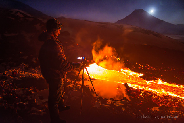
lava, gas, pyroclastic flow
Volcanic Hazards
Volcanoes can be exciting and fascinating, but also very dangerous. Any kind of volcano is capable of creating harmful or deadly phenomena, whether during an eruption or a period of quiescence.
Volcanoes can be exciting and fascinating, but also very dangerous. Any kind of volcano is capable of creating harmful or deadly phenomena, whether during an eruption or a period of quiescence.
Gases
Volcanic gases are probably the least showy part of a volcanic eruption, but they can be one of an eruption's most deadly effects. Most of the gas released in an eruption is water vapor (H2O), and relatively harmless, but volcanoes also produce carbon dioxide (CO2), sulfur dioxide (SO2), hydrogen sulfide (H2S), fluorine gas (F2), hydrogen fluoride (HF), and other gases. All of these gases can be hazardous - even deadly - in the right conditions.
Volcanic gases are probably the least showy part of a volcanic eruption, but they can be one of an eruption's most deadly effects. Most of the gas released in an eruption is water vapor (H2O), and relatively harmless, but volcanoes also produce carbon dioxide (CO2), sulfur dioxide (SO2), hydrogen sulfide (H2S), fluorine gas (F2), hydrogen fluoride (HF), and other gases. All of these gases can be hazardous - even deadly - in the right conditions.
Pyroclastic Falls
Pyroclastic falls, also known as volcanic fallout, occur when tephra - fragmented rock ranging in size from mm to tens of cm (fractions of inches to feet) - is ejected from a volcanic vent during an eruption and falls to the ground some distance away from the vent. Falls are usually associated with Plinian eruptive columns, ash clouds or volcanic plumes. Tephra in pyroclastic fall deposits may have been transported only a short distance from the vent (a few meters to several km), or, if it is injected into the upper atmosphere, may circle the globe. Any kind of pyroclastic fall deposit will mantle or drape itself over the landscape, and will decrease in both size and thickness the farther away it is from its source.
Pyroclastic falls, also known as volcanic fallout, occur when tephra - fragmented rock ranging in size from mm to tens of cm (fractions of inches to feet) - is ejected from a volcanic vent during an eruption and falls to the ground some distance away from the vent. Falls are usually associated with Plinian eruptive columns, ash clouds or volcanic plumes. Tephra in pyroclastic fall deposits may have been transported only a short distance from the vent (a few meters to several km), or, if it is injected into the upper atmosphere, may circle the globe. Any kind of pyroclastic fall deposit will mantle or drape itself over the landscape, and will decrease in both size and thickness the farther away it is from its source.